

Written by: Tristan Craig.
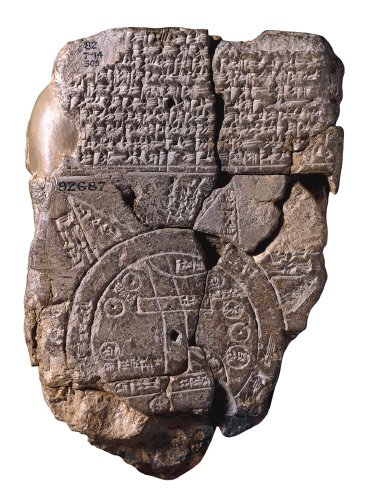
Engraved on a clay tablet and labelled with cuneiform script, the sixth-century BCE Babylonian Imago Mundi or ‘image of the world’ is one of the oldest examples of cartography known to exist. Its depiction of the Mesopotamian Empire, with land and ocean masses carefully rendered on its surface, illustrates both the interest in geographical enquiry and limitations of global exploration for this ancient civilisation. This small tablet, having suffered a great amount of damage in the last three millennia, also exemplifies the complexities of attempting to understand an archaic worldview. By the Middle Ages, cartographic practices showed increasing scope and refinement due to expansions in world trade, however there remained a large disparity between maps which attempted to depict an accurate world view and those which served a predominantly ecclesiastical purpose.
Whilst the modern geographic map attempts to render topographical features in a manner as accurate as possible, cartography in the Middle Ages was less concerned with depicting physical space as it was abstract beliefs. As Christianity gained traction in the West, so too did ways of glorifying the omnipresence of God, with mappae mundi (‘world maps’) created to centralise the church on a global plane. The T-O format of map production – so called because of the T shaped bodies of water intersecting the landmasses of a disc shaped earth – was popular in the medieval period. In a tradition which originated toward the end of the Roman Empire, these depict a tripartite Earth with the continents of Asia, Europe, and Africa divided accordingly. Little was known of the antipodean landscape, presumed habitable only by beasts and monstrous creatures. The only completely surviving example of this medieval mapping tradition is the late thirteenth-century Hereford Map, named after the cathedral in which it is interred. With Jerusalem placed prominently in the centre and the biblical land of Paradise in the northernmost reaches, the emphasis in this mappa mundi is on the placement of Christianity in the medieval world. Whilst the inclusion of landmarks and terrain suggests at least some knowledge of global geography, its primary function as tool for teaching Christian doctrine is evidenced by its centring of the faith.

Despite their commonality, the tripartite map was not the sole format used in the Middle Ages, however; beyond the realm of Christianity, cartographic practice on occasion showed a far greater attention to geographical precision. Bearing a closer resemblance to the modern atlas, Moroccan cartographer Muhammad al-Idrisi created a series of illustrations under the patronage of King Roger II of Sicily which, when combined, formed an entire world view. The resulting world map and accompanying text was entitled the Nuzhat al-mushtāq fī ikhtirāq al-āfāq or Tabula Rogeriana (‘Map of Roger’) and, despite being created over a century prior to the Hereford Map, is remarkable in its accuracy. Drawing upon his own journey from North Africa to the Mediterranean, evidence shows that al-Idrisi was well versed in creating portolan charts – maps depicting sailing directions and naval trade routes – and his seafaring knowledge is clearly represented in the Tabula Rogeriana. Each important town or city is indicated by a brown circle, the majority of which are located along the Arabian Peninsula and southern Europe in correlation with al-Idrisi’s own travels.
Particularly striking is the south-up presentation of the map which was common in early Islamic cartography, before what is now considered ‘north’ became the accepted standard. The dichotomy between north and south, and their representation in early maps, is indicative of the role the map played in representing religious and political power struggles. Similarly, the prominence of the Italian peninsula in the Tabula Rogeriana, with its multitude of coastal trading hubs, may have been included to appease the commissioner of the work: the King of Sicily. To that end, the map also serves to tell us a great deal about the relationship between al-Idrisi and Roger II, a Muslim Arab scholar and a Christian monarch, in actualising this geographical work. Muhammad al-Idrisi himself hailed from Moroccan nobility with his aristocratic lineage having the potential to benefit the expansive aspirations of the Sicilian king. Incidentally, the map includes little about inland territories, further suggesting its purpose as a type of portolan chart. That it was created over a period of fifteen years, with frequent discussion held over its accuracy, denotes the attention to detail paid by al-Idrisi – in sharp contrast to the far more symbolic Hereford Map.
Developing a nuanced understanding of the work rests largely on interpretation of the extant copies, however al-Idrisi’s map falls foul of a problem commonly facing medievalists. Unfortunately, as with the majority of manuscripts from the High Middle Ages, the original book containing al-Idrisi’s maps and an engraved silver disc commissioned by Roger II have since been lost. Two extant manuscript copies of the Tabula Rogeriana are currently housed in the Bodleian Library, one of which dates from 1553 CE and contains his complete work. More recently, a 1929 facsimile was created by Konrad Miller to depict how al-Idrisi’s original illustrations would have looked when combined to create an entire world view as intended. Even when objects – such as the sixth-century BCE Imago Mundi – have survived millennia, their condition can present a plethora of problems, from analysing the map to ensuring its subsequent preservation. The intricate mappae mundi of the High Medieval Period existed as unique works of art. Fortunately, the existence of manuscript copies of al-Idrisi’s map allow the modern historian to view it how it would have appeared in lieu of the original.
As navigational tools, medieval maps are largely limited in their accuracy. Although global knowledge expanded as trade routes increased throughout the period, the influence of both ecclesiastical and secular politics infiltrated the development of map making. From the power of religious veneration to the prominence of mercantile activity in particular territories, maps tell us as much about the personal beliefs of the individual creating them as they do geographical information. Perhaps the most striking revelation of Muhammad al-Idrisi’s Tabula Rogeriana is not just in his accurate depicting of physical space but in the extent of global travel and cultural exchange in the twelfth century. It is vital that the modern historian observe the medieval map not just as an artefact judged on what it renders but as a product of an individual and the society in which they lived.
BIBLIOGRAPHY
Ahmad, S. Maqbul. “Cartography of al-Sharīf al-Idrīsī,” in The History of Cartography Vol. 2 Book 1: Cartography in the Traditional Islamic and South Asian Societies, ed. J.B. Harley and David Woodward (Chicago, 1992).
Black, Jeremy. Maps and Politics (London, 2000).
Edson, Evelyn. The World Map, 1300-1492: The Persistence of Tradition and Transformation (Baltimore, 2011).
Hartnell, Jack. Medieval Bodies: Life, Death and Art in the Middle Ages (London, 2018).
Vernet-Ginés, J. “The Maghreb Chart in the Biblioteca Ambrosiana,” Imago Mundi 16 (1962): 1-16.
