
Written by Emma Marriott.
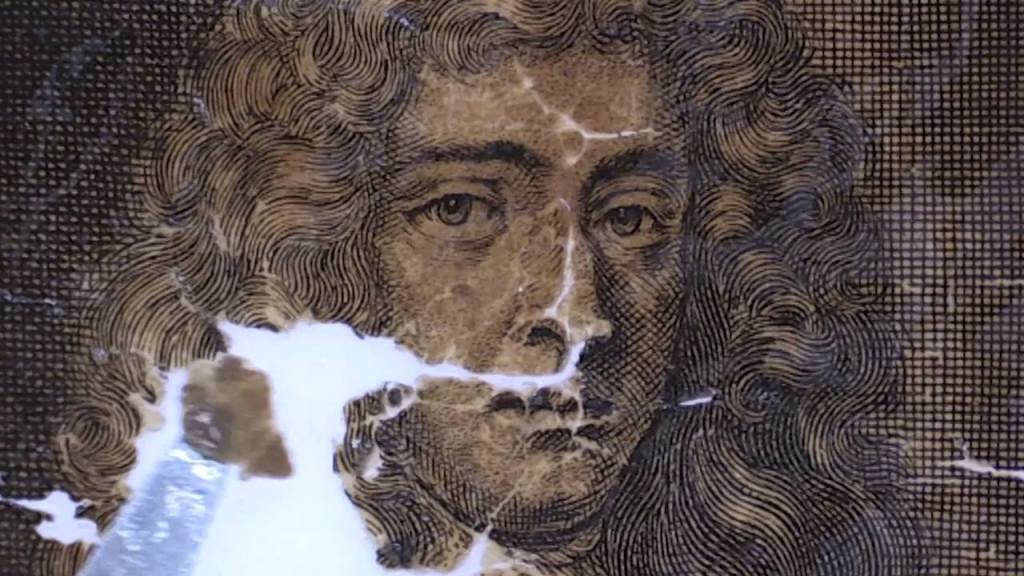
In the heart of Edinburgh, our University and the National Library of Scotland (NLS) have been working in collaboration to research the mystery that is known as the restoration on the ‘Chimney Map’. Fifteen years ago a rare antique map was deposited into the NLS after having been found in a rural country house in Aberdeenshire. The map is now dated as a seventeenth-century map of the world, and there are only two other known copies in existence. It had been rolled up in a shambolic ball and stuffed up a chimney, and now lies out, restored to a condition that little believed possible, thanks to the time and careful attention of Claire Thomson, Conservator at the NLS.
Now that the map has been restored and can be studied, Dr Esther Mijers of the History Department sought four student researchers, Amy Hollander, Sarah Thew, Julia Weingaertner, and Emily Hall (from the University’s The Student), to embark on a ‘fact-finding’ research project during the Festival of Creative Learning in February to provide some insight into the origins of the map. It was a fascinating discussion to have been privy to as these four girls demonstrated very extensive and concise research, and they each embarked on their own avenues of interest such as the genealogy of the potential owners of the map, the map makers themselves and the smaller maps that bordered the main centre piece. Sarah considered the ownership of the map, and it proved more difficult to her than she originally thought. Most owners all seemed to be called Robert Gordon. She then studied parish records to find the dates for the Gordon family’s ownership of the Cluny Estate, to whom it is believed that the map was owned by. She pegged joint ownership of the estate in 1687 when a Robert Gordon married Katherine Arbuthnot, who outlived Robert, and was written down in a parish record as ‘Lady Dowager of Cluny. She looked into the Arbuthnot name and found that a church on their land was home to one of the first ministers of the Protestant faith after the Scottish Reformation. Sarah concluded that she believed that by the third branch of the Gordon family, they were steadfastly Protestant.
Julia found that the small inscriptions and drawings around the border of the map were illustrations of European cities, which were either capitals and well-established trading centres. For example, one illustration was of Batavia, which was the capital city of the Dutch East Indies. Batavia now corresponds to the present-day city of Jakarta, the capital of Indonesia. Her research into the etchings of the map has spurred her interest with a possible connection to Rembrandt, as there may have been a specialized market pool of specialized professionals there. A significant feature of the Chimney Map which sets it apart from other maps of its era and its kind is the frequency of illustrated churches surrounding it. Emily embarked on a research path that looked into the significance of these churches. There are six labelled churches on the map in total, and Emily looked to identify the Church labelled Ulster, and considered the copper plates, etchings, and focused on the typology in Dutch art. She suggested that the copied maps in the British Museum did not have the same focus on churches. The group highlighted that this may be due to the religious uncertainties that were experienced in Scotland in the later years of the seventeenth century. Scotland’s monarchy was politically and religiously problematic in this period, as King James VII and his wife, Anne Hyde both converted to Roman Catholicism in 1667 and, following her death in 1671, King James married the Catholic Mary of Modena, who many viewed as an agent of the Pope. Emily highlighted that that the religious paintings in the map focused more heavily on the Old Testament, such as David’s fight with Goliath, which she suspected was a demonstration to Scotland’s underdog, but persistent presence in global movements.
Amy Hollander’s research delved into the social aspects of the map and what it reveals and about society of the time. On the map are featured the images of King William III and Queen Mary of Orange in the middle of the map, the new Protestant monarchs of Britain in 1689. The images of William and Mary may highlight the religious tensions between Catholicism and Protestantism in Scotland at the time. Amy considered the migration of Scots and Scottish Kirks to Rotterdam, which
had become a port at the centre of a trading empire, as the Dutch were one of the first nations in Europe to value trade more than just religion. The Dutch took in many religious refugees from across Europe, including Scots, whose Calvinistic views were tolerated by the Dutch state. The Scottish religious refugees in the Netherlands saw William as their future Protestant hero, with great expectations. However, their hopes were dashed, as William seemed less interested in Scotland and, as a further insult to injury, the massacre at Glencoe in 1692 further deepened negative Scottish public opinion of William. Maps of this size and statute symbolized power and prestige, designed to demonstrated knowledge and were considered to exhibit colonial importance, that which William and Mary were a part of. Furthermore, the inclusion of the celestial designs was modern for the late-seventeenth century.
The evident excitement in this project was undeniable and the motivation from seeing the physical map stimulated the students’ research on these varied topics of colonialism, religious and political tensions, and the genealogy of ownership. The map demonstrates the shift from divine wisdom to human wisdom, and thus brings cartography into modern history. This map helps connect the dots of Scottish and Dutch history and challenges traditional assertions of such history. Emily stated that ‘the map was an interesting example of humanity’s attempt to map their knowledge of the natural and human world’. The girls’ enthusiasm was infectious, and Dr Mijers’ organisation of the project definitely suggests that research leads to practical understanding and greater learning.
